

This section outlines the technical specifications and operation of the Cordel Wave-OEM.
System Architecture
The Cordel Wave-OEM is used to capture Lidar, INS, and imagery data for Cordel Cloud services. This data is used to provide a digital twin of the mapped corridor for the automated analysis of assets. The Cordel Wave-OEM consists of three sensors: Lidar, INS (Inertial Navigation System), and Imagery. These sensors are logged, monitored, and controlled via a Control Unit housing an onboard computer (OBC) and networking devices. The control unit provides a user network port and can be accessed via Cordel Ground Station to view and monitor sensor statutes and actions. A 24VDC power source is provided to the Control Unit and is passed through to the associated Sensors. The INS sensor is provided with two L1/L2 GNSS (GPS) antennas in order to geo-reference the system. Please refer to the figure below for reference.
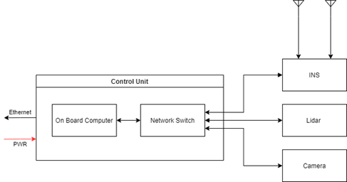
Cordel Wave OEM Architecture
Functions
The Cordel Evaluation Kit On-Board Computer performs the following functions:
-
Automated Logging of LiDAR data
-
Automated Logging of INS data
-
Automated Logging of Imagery data
-
Storage of sensor data in a 256GB FIFO (First in First out) buffer
-
Storage retrieval services for data flushing
-
Sensor health monitoring telemetry stream
-
Power supply unit for peripheral sensors
-
Networking-based telemetry routing for a Wi-Fi/LTE network-connected system.
The Cordel Wave-OEM acts as a data logger for various sensors. Data can be uploaded using the Cordel Uploader to be used with the Cordel Cloud solution for data analytics.